


Webcams Reveal New Clues to Characterising Iceland's Volcanic Eruptions
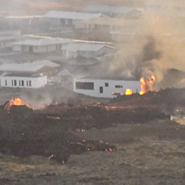
Webcam footage capturing the destruction of homes in Grindavík January 2024
After around 800 years of relative quiet, volcanic activity resumed on Iceland's Reykjanes Peninsula in 2021, prompting scientists to investigate where future eruptions are most likely to occur. New research from Oxford Earth Sciences has revealed how lava from previous eruptions and the surrounding landscape influence where new eruptive fissures open and how fire-fountain heights vary during fissure eruptions, improving understanding of the processes that control fissure eruptions.
The recent eruptive episode began with three eruptions at Fagradalsfjall, which became popular tourist destinations because the surrounding topography helped contain the lava flows. Activity later shifted to the neighbouring Svartsengi Volcanic System, where lava can spread much more freely across the landscape. This has created a far greater hazard for visitors, residents of the nearby town of Grindavík and critical infrastructure, including the Svartsengi Power Station, which supplies electricity and hot water to Reykjavík. Lava from the Svartsengi eruptions has already damaged homes and infrastructure in Grindavík, highlighting the importance of understanding where future fissures are most likely to open.
To investigate this, the researchers analysed continuous livestream footage from a network of public webcams alongside aerial and satellite imagery. Although the cameras were installed to allow people around the world to watch the eruptions unfold, they also provided an unusually complete real-time record that enabled the team to measure changes in fire-fountain height during the first three hours of each eruption, while mapping fissure locations using aerial and satellite imagery.
Each eruption changes the conditions for the next. Rather than repeatedly opening along the same fractures, new fissures are redirected by the landscape and by the weight of lava from previous eruptions. Understanding these processes allows us to better anticipate where future volcanic hazards are most likely to develop.
- David Pyle, co-author of the study
The study found that new fissures do not simply reopen along the paths of earlier eruptions. Instead, their locations are strongly influenced by both the surrounding topography and the weight of lava deposited by previous eruptions. Together, these factors led to a progressive eastward shift in fissure locations over successive eruptions.
The researchers also found that elevated terrain can deflect fissures and that preexisting structural weaknesses, such as the Hagafell zone of weakness, may only be reactivated after multiple eruptions have weakened the crust. These findings identify areas that are more susceptible to future fissure opening and improve predictions of where the longest and most hazardous lava flows may develop.
The webcam footage also provided new insights into how fire fountains behave during fissure eruptions. While previous studies have largely focused on eruptions from single volcanic vents, the researchers found that fire-fountain heights vary considerably along the length of an eruptive fissure and through time. The tallest fountains consistently formed on the first fissure segment to open, typically within the first few minutes of an eruption. Variations in fountain height between fissure segments were primarily controlled by the length of each segment, continued dyke propagation, and each segment's timing and proximity to where the eruption began. These observations provide new insights into how fissure eruptions evolve in their earliest stages and could help scientists better interpret future eruptions as they unfold.
As someone who used to be one of the volcano enthusiasts watching the eruptions on YouTube while working, it's been amazing to use those same videos to extract so much valuable information. With the volcanic system continuing to recharge between eruptions, understanding where future fissures are most likely to open has never been more important.
- Rebekah Rhodes, lead author of the study
The findings also demonstrate the scientific value of publicly accessible webcam networks. Although the cameras were not designed for research – and their changing positions and zoom levels made automated analysis impossible – they captured details of the eruptions that would otherwise have been difficult to observe. Future webcam networks designed to support both public viewing and scientific monitoring could provide even richer datasets during volcanic crises, improving both research and hazard assessment. As volcanic activity continues on the Reykjanes Peninsula, combining public engagement with scientific monitoring could provide valuable new data to improve our understanding of future eruptions and support hazard assessment in real time.
Having gotten my fix of volcanoes during the pandemic by watching the livestreams of Fagradalsfjall erupt, it was exciting to use those videos for science!
Professor Tamsin Mather, co-author of the study
The study “Fissure locations and fire-fountain dynamics during the December 2023–September 2024 Svartsengi Volcanic System eruptions, Iceland, from aerial imagery and recreational webcam footage” is available to read in Bulletin of Volcanology at https://doi.org/10.1007/s00445-026-02006-3.
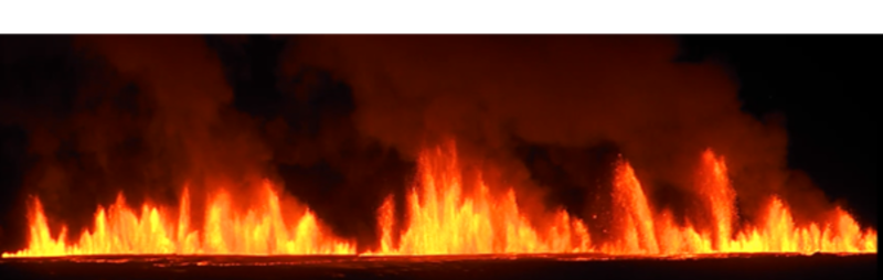
Webcam footage of the eruptions

